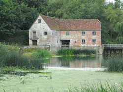
 Sturminster Marshall mill
 DAY 1 - Blandford to Sturmninster Newton (13.5 miles)
10/09/13
And so to the final stages of the Stour Valley Way. I had a week off work and had planned to use some of it to finish the SVW. Having walked the first half as practice for the Coast to Coast, I was keen to complete this and follow the river Stour from the sea at Christchurch to its source at Stourhead, 64 miles earlier. A bit of planning was involved, as there was only one campsite convenient to the path. I booked 2 nights at 'Osho Leela' on 10th and 11th September and walked from Blandford Forum to Sturminster Newton on day 1, getting the bus onwards to Gillingham to camp there overnight. Pete dropped me off at Blandford and I waved goodbye to him for the next 2 nights and set off walking at 9.30 am. I needed an early start as the last bus from Sturminster to Gillingham was at 16.20 and I did not want to miss it!
The walk initially goes through the grounds of the rather exclusive Bryanston School (£10,738 a term, with very impressive equestrian facilities in case you were wondering) and into the very small village of Durweston. From there I was on familiar territory as I crossed into Stourpaine and then up and over the Iron Age forts of Hod Hill and Hambledon Hill, where I stopped for lunch and watched a kestrel using the thermals to hunt. Also spotted many Adonis Blue butterflies, nice to see, and probably the last of the summer's swallows. I had been tempted by a new trailway at Stourpaine which uses disused railway track all the way into Sturminster Newton, but why miss out on the hills. And I know how much I would have been bugged by not sticking to the official path, even it is a part I've done several times before. It was bad enough getting OCD in the car on the way to Blandford because I had put my clean clothes in the green dry-bag instead of the usual blue one! Guess what I did first when I got to the campsite....As it turned out, I picked up the trailway just beyond Child Okeford due to diversions and headed for Fiddleford Mill and the 14th century manor house there. Unless I missed something, I didn't see much of the mill, but the weir there was interesting and reminded me of a smaller version of Pultney weir at Bath. There was a little hydro-electric plant that worked with an archimedes screw housed inside a wooden shed and down a shute, which I thought was a hatching shed for eels or fish! It blended really well with the old buildings and provided enough power for 35 houses - not much, but every little helps.
From Fiddleford it was a short walk into Sturminster Newton, staying close to the river and crossing fields to reach the pretty old market town which was once home to the largest calf market in Europe, fact! Thomas Hardy lived here for a while, as did his contemporary the Dorset dialect poet William Barnes. As I had plenty of time before the bus to Gillingham, I popped into the local co-op for some groceries and had a coffee at Poets Corner cafe with its resident budgies Bobby and Bluebell. Short bus trip to the outskirts of Gillingham and then another mile or so to the campsite at Osho Leela, a spiritual retreat come hippy community come personal development kind of place (I was too early for the autumn conscious sexuality festival and the humaniversity classes, shame). I was slightly afraid I might be forced to participate in some tantric sex workshop or have to discuss my private parts at a gender-balanced intimacy group, but fortunately not. The site was quiet and secluded with good showers if you didn't mind sharing them with the spiders and daddy-long-legs. A little black cat from the nearby farm watched me set up camp. She sat in the hedge for ages, but I couldn't persuade her to come over. Saw her later with a mouse for her supper as I was tucking into bacon butties for mine.
Was thinking that today had been a Keats day - season of mists and mellow fruitfulness as his Ode to Autumn has it. The hedgerows were brimming with fruit and nuts. I picked and ate several ripe plums, loads of blackberries (obviously not the ones at the bottom of the hedge...) and there were also rosehips, haws, elderberries, sloes, quince - even grapes and pomegranate in a cottage garden. Then there were acorns, beech nuts, hazel nuts and horse chestnuts. Watched an amazing sunset and drifted off to sleep listening to owls. Got up about 2.30 for the loo - the night sky was so clear I could recognise constellations, but not sure exactly which ones - something to swot up on.
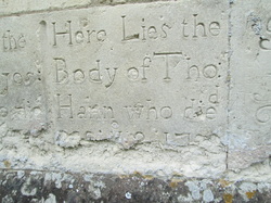 Gravestones in the church wall at Marnhull
 DAY 2 - Sturmninster Newton to Gillingham (13.5 miles)
11/09/13
Walked the mile or so into Gillingham town centre this morning and caught the bus back to Sturmninster Newton in order to walk back into Gillingham! This is what happens when there is only one campsite for miles around. I found Gillingham rather dismal and much preferred the rural charm of Sturminster. Once there, I took some time to look around the town and walk down to the mill which, amazingly, is actually by-passed by the official route. The mill is beautiful and is still producing flour.
If yesterday was Keats, then today was definitely Hardy with a bit of Tennyson in the mix for good measure. The walk followed the river much more closely today as it meandered through the Vale of Blackmore (Hardy's Vale of the Dairies). In places the river put me in mind of Tennyson's Lady of Shallott (on either side the river lie long fields of barley and of rye, that clothe the wold and meet the sky...and so on down to Camelot) and of the famous pre-Raphaelite painting by Waterhouse. No chance of meeting a Lancelot on a shining charger for me though, and even if I did the backpack would probably be too heavy for him to sweep me off my feet! Heard the distinctive 'splosh' of a water vole, but didn't actually see it. And although there are otters in the Stour hereabouts, I was out of luck there too. But it's nice to know they are there.
It was difficult to navigate today as the path wasn't very well signed and the fact that some fields that it crossed had been ploughed over made it impossible to find in places, so a bit more walking along the lanes than I had anticipated, and where I did cross fields I was herded out of them twice by some very pushy bovines. I don't know if it was the sticks, but I got the distinct impression they wanted me out of their fields, and be quick about it. I felt like I was playing that primary school game 'What's the time Mr Wolf' as every time I turned round the cows were following me again. And yet when I (rapidly) crossed the field and stood safely on the other side of the fence it seemed that all they wanted to do was sniff me and have a lick of my hands. Weird. Just glad I didn't have a dog or else I think I might have been stampeded. Also good (I think) that I don't mind having my hands licked by cows.
My lunch stop was at Marnhull, which I loved. It is a beautiful village which Thomas Hardy also walked to in 1877 during his 2 years living at Sturminster, probably along the same paths. He saw the old May Day procession there, which features in Tess, and used the village as her birthplace, which he calls Marlott. I sat in the churchyard of St. Gregory's and wondered if the gravestones set in the wall were his inspiration for the D'Urberville graves that made plain Tess Durbeyfield think she came from a noble family. The Crown Inn is called The Pure Drop in the book and the oldest part of the pub has not been changed much since the 16th century. I sat in a small room with original wood panels and pondered if this is where Hardy imagined Tess' father downing many a pint. I only had an Appletize. Leaving Marnhull and Hardy behind, I continued to follow the river by more mills then across fields and along lanes to the wonderfully named Fifehead Magdalen and Stour Provost (so I'm now thinking about Betjeman's poem 'Dorset', what a literary trail this is turning out to be). Ate some scrumptious tomatoes from honesty box at Fifehead and left the money in the letter box on the garden gate. There were lots of stunning cottages and houses, and every car that went past was clearly very expensive, but my oh my, how grumpy all their drivers looked. All that money and they couldn't even crack a smile as a passing walker raised a friendly hand to greet them. I was worried that most of them wouldn't even pull out around me. Bally toffs.
It was raining heavily by the time I got back to base, so much so that I found a little leak in the outer of the tent so will have to attend to that when get home. It's into the lobby bit so not going to get wet from it. Cooked in the lobby bit with head torch on, which is great for attracting daddy-long-legs. They go straight for your face as that's where the light's coming from and when you bat them away they fall into your dinner. They have now taken over from midges as my least favourite flying beasties. No sign of the cat tonight, too wet! Have been totting up the expenses and they come to a grand total of £37 for the trip - not bad for three days away.
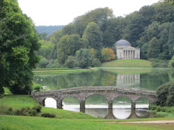 Stourhead Gardens from the village
 DAY 3 - Gillingham to Stourhead (10.5 miles)
12/09/13
So this is where the rest of the hills are! Lulled into a sense of security be having got what I thought were the big hills out of the way on Day 1, today came as a bit of a surprise. Although I'm not sure why it didn't occur to me that as you got nearer to the source of a river you might be a) up hill and b) across valleys, but there you go. And there I went. It was a damp start as I packed up, but the rain soon cleared so I didn't need my waterproofs. Was glad I hadn't got gortexed up as it got hotter and hotter as the day went on.
Again there was a lack of waymarkers today. Day 1 I pretty much knew the route, Day 2 I had a good idea from the bus trips, Day 3 I would have been completely lost a few times so was glad I had saved the GPS batteries for the last day. I was also using a Landranger map on a 1:40000 scale rather than my usual Explorer maps on a 1:25000 scale, so everything seemed further away than it looked on the map.
I had arranged to meet Pete at the Spread Eagle pub in the village next to Stourhead at 4pm and thought that would give me plenty of time, but the many faffs to get the rucksack over narrow stiles and through tiny kissing gates together with the several hours (or so it felt) it took me to wait for a safe gap to cross the A303 did mean getting a bit of a rush on at the end. My legs were knackered by the time all was done but there had been some serious power walking along the flat parts and several steep ascents and descents. Again, I was grateful for the flask of coffee that Pete had brought with him, and for his patience as I didn't actually get to him until 45 mins after I had said I would.
This last part of the walk was very scenic, with views of the Wessex Ridgeway on my left for most of the day. I'm tempted to do some of that next, weather permitting before putting the tent away for the winter. I stopped for lunch at Silton, a tiny village with a population of just 134, and a gorgeous little church. You may have noticed that I'm quite partial to stopping for lunch in churchyards and today's was particularly picturesque. It was on a hill that fell steeply away to give views over the vale below. Sitting in the walled churchyard I could hear the church organist practicing some well known hymns. I went into to have a look and was taken aback by how lovely the church was inside. The original green, red and gold colourings had been restored to the walls and arches, the roof bosses shone with gold leaf and the massive memorial to a local dignitary from Charles II time dominated one wall with its life-sized statues.
Next came Bourton with the remains of a WW1 ordnance factory where Mills bombs were made in vast quantities. Bourton is also where the three counties of Dorset, Wiltshire and Somerset meet. I thought about standing with a foot in each, but then remembered I only have two feet. From there it was the last of the ups and downs through the Stourhead Estate to reach the source of the river itself. The estate is magnificent, and you can glimpse the formal gardens and the Temple of Flora from the high ground above. Then you skirt the gardens (thus avoiding the entry fee) to come to Six Wells Bottom. By this point I was flat out to try to get to Pete for 4 o'clock, but I was determined to get to St. Peter's Pump which marks the source. The pump looks like an old church steeple and dates from 1474. It was originally part of old Bristol's water supply, but was moved here for some reason in 1768. See my photos from the walk here. Anyway. I quick marched it to the pump and back towards the house. I was surprised that the path went for free right in front of the stunning Palladian mansion, which looks like it has been used in many a film set. Few piccies there and then down to the picture postcard village of Stourton where the view into the gardens and across to the Pantheon is stunning. Big hugs from Pete and home to the pussy cat boys and the rest of the week off. New hall floor and repainting hall, stairs and landing. Nice. And here endeth the Stour Vally Way, job done. I've also re-sealed the leaky bit on the tent.
 RSS Feed
