
It was time to head for the hills. It's all very well covering long distances on the flat, but I have to start getting some hills in. Not being one to do things by half, I decided to walk the Dorset Stickler route again. This 11 mile route is also known as the 'Dorset 3 Peaks Challenge' as it covers 3 of the highest hills in the county - Hod Hill, Hambledon Hill and Okeford Beacon. It's usually done as a race by the Dorset Doddlers - bonkers if you ask me! The fastest 2012 time was 1 hour 7 mins; we took a mere 5 hours, and we actually did nearly 12 miles. I had unintentionally adapted the route slightly due to not having one of the three OS maps and having to plot a page from memory using the OS get a map site (which is brilliant for plotting your own routes and downloading directly to GPS - if only I could get the GPS to talk to new Windows 7 laptop.....) Isn't it a pain when your walk is on the edges of three different maps?!
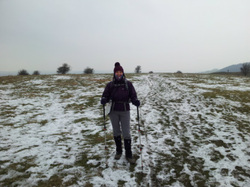
Pete was coming with, Annie & Grae picked us up at 10.30 (needed a lie in this morning), and we headed off to Stourpaine to start the walk. It was a fine day, but very cold. We set off at about noon and headed for Hod Hill (439 ft) , an easy climb to start the walk. This is an Iron Age fort, with a Roman camp as it was captured by them in AD 43. Next, after a small section of the Wessex Ridgeway, was Hambledon Hill (630 ft) which was occupied as far back as the Stone Age and is a wonderful and atmospheric example of an Iron Age fort. We passed some paragliders climbing up with their canopies in large backpacks and stopped for lunch in the shelter of an embankment. Then we passed through the pretty village of Child Okeford and dropped down to its somewhat uglier cousin Shillingstone to start the long, tough climb up Okeford Hill (731 ft). This did seem like hard work! Eventually we reached the beacon, which was last lit for the Queen's diamond jubilee. The rest of the walk was downhill / level across fields and lanes to Durweston and back to the White Horse at Stourpaine for a couple of well deserved drinkies. I definitely need to get more hills in - Okeford is a mere tussock compared to the Lake District. I think will try another hilly walk on Bank Holiday Monday. Highlight of the day was definitely the Iron Age forts, and walking with friends as the sun struggled to shine.
Pete was coming with, Annie & Grae picked us up at 10.30 (needed a lie in this morning), and we headed off to Stourpaine to start the walk. It was a fine day, but very cold. We set off at about noon and headed for Hod Hill (439 ft) , an easy climb to start the walk. This is an Iron Age fort, with a Roman camp as it was captured by them in AD 43. Next, after a small section of the Wessex Ridgeway, was Hambledon Hill (630 ft) which was occupied as far back as the Stone Age and is a wonderful and atmospheric example of an Iron Age fort. We passed some paragliders climbing up with their canopies in large backpacks and stopped for lunch in the shelter of an embankment. Then we passed through the pretty village of Child Okeford and dropped down to its somewhat uglier cousin Shillingstone to start the long, tough climb up Okeford Hill (731 ft). This did seem like hard work! Eventually we reached the beacon, which was last lit for the Queen's diamond jubilee. The rest of the walk was downhill / level across fields and lanes to Durweston and back to the White Horse at Stourpaine for a couple of well deserved drinkies. I definitely need to get more hills in - Okeford is a mere tussock compared to the Lake District. I think will try another hilly walk on Bank Holiday Monday. Highlight of the day was definitely the Iron Age forts, and walking with friends as the sun struggled to shine.


 RSS Feed
