Day 9 - Keld to Reeth
01.07.13
DISTANCE WALKED: 11.7 miles
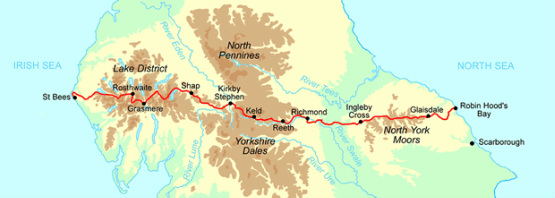
What a glorious walk I had today, and another dry day at that. Today there was another choice between a low level route along the River Swale or a high level route across the moors. My head and legs were telling me to have an easy day and take the riverside route. My heart was telling me to go with the high one, and sometimes you just have to follow your heart! Until the early 1900's, Swaledale was at the heart of Yorkshire's lead mining industry and produced 10% of the world's lead. My walk took me through the remains of old lead mines and smelting mills, across grouse moors and into proper James Herriot country at Reeth.
The trail leaves Keld and climbs to cross the Pennine Way near the ruins of the wonderfully named 'Crackpot Hall,' where there have been buildings dating back to the 1600's. The current ruin was a farmhouse built in the 1800's, was once owned by one of the mine's managers and abandoned in 1950 due to subsidence. Crackpot does not refer necessarily to any of the former residents, it is derived from an old Viking word for "deep chasm that is a haunt of crows." The ruins of Swinner Gill mine seem improbably placed at the bottom of a steep gully, which I took the very difficult but beautiful path up alongside a series of waterfalls only to see that there was a better, newer path that met it at the top! Once again I have gone 'off piste' from the guidebook, but once again I think I had the better walk for it.
Crossing Gunnerside moor, and down another steep gully, the next ruins are of Blaikethwaite, with its large peat store to fire the smelt mill, and a well preserved kiln. This made a lovely lunch stop; with my boots off by the beck I was very nearly tempted to a paddle. But I'm saving myself for that dip in the North Sea at Robin Hood's Bay. There was a steep climb up and over the gully, onto Melbecks moor and then one more push up the very steep and rocky ravine of Bunton Hush to reach a stony plateau, which is the spoil of a technique called 'hushing' by the old mining industry and now used for 'winning' (i.e. reclaiming) gravel. A hush is a ravine on a steep slope formed when prospectors suddenly release water that has been artificially dammed above it. The force of the torrent strips the vegetation and scours the ground with the aim being to expose any mineral content that might indicate the presence of a vein. This has left the landscape bare and AW refers to it as 'an arid desert of stone.' I came across this patented stone crusher and kibbler along the gravelly 'moon walk'. The old miners tracks do make for an easy descent down to the best preserved ruins of the day.
One of the buildings at Old Gang Mines still has the wooden hoppers on a rusted rail and it is easy to imagine the thousands of workers from the villages here abouts (Keld once had a population of 6000 and is now just a tiny hamlet) toiling hard for not much money. And it was only four generations ago that the mines closed, so that would be great-great-grandparents suffering appalling conditions underground and even having to hire their tools from an agent. Meanwhile the mine owners were becoming fabulously wealthy. It's enough to make you Marxist.
Leaving the mines behind, the trail passes through grouse moors (tick, I saw a red grouse). It's horrid to see lines of grouse butts and I can't think what possesses anyone to think that sitting in one of them shooting defenceless birds bred and released solely for their entertainment is fun. Harumph. At Surrender Bridge the trail then crosses the road to Arkengarthdale (I just love these names) before the very steep down and up at Cringley Bottom (no sign of Noel Edmunds, thank God). AW writes 'the descent into the ravine is steep, and most safely accomplished by shuffling down on your bottom.' So I was lucky not to have another comedy fall here. A final push up and across High Healaugh Moor, where the views across the dale and down to the river are splendid. It seemed rude not to pop into the Buck Inn for a cheeky half on the way past. I went back later for a huge jacket potato with Wensleydale cheese and caught up with the remaining folk from our little cohort to compare tales of the day's walk. Tomorrow, Richmond. Tonight, sleep.
Today's tunes: "A message to you, Rudy" by The Specials, The Bee Gees (when they were still folk singers and before they went all falsetto) "New York Mining Disaster 1941" and The Police "Walking on the Moon."
Odometer
11.7 miles
Cumulative Miles
118.7
Total Ascent
776 metres
Total Descent
847 metres
Moving Time
4h 27 m
Stopped Time
2h 39 m
Moving Average
2.6 mph


