Day 15 - Grosmont to Robin Hoods Bay
07.07.13
DISTANCE WALKED: 16.1 miles
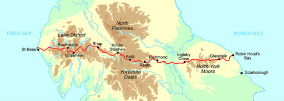
I did it! I have walked 207 miles from one side of the country to the other, climbed the equivalent of Everest, crossed the Lake District, the Eden Valley, the Pennines, the Yorkshire Dales, the Vale of Mowbray and the North York Moors. Phew. What an experience and although it was difficult at times, I have enjoyed every step and have seen absolutely some of the very best scenery that my beautiful country has to offer. I have relished walking on my own and have met some wonderful people along the way with whom we have swapped interesting tales, offered moral support to each other and who have looked out for me coming in at the end of each stage - special thanks to Greg and Clare from Southampton who had the same itinerary as me and were often in the same B&B's. Also to Peter and Esther, James and Dain, Wayne and Mary, Madeline, the Quiet Americans and The Danes.
AW ensures a fitting culmination to the walk, and it did not disappoint. It was a bit of a reprise of all the different days so far: rivers and moors, woodlands and waterfalls and, of course, the cliff path to journey's end at Robin Hood's Bay. And of course, enough ups and downs to ensure you arrive at RHB suitably dishevelled (especially so on the hottest day of the year!) He wrote "You will really enjoy this last section, whatever the condition of your blisters, so much that you will regret leaving behind each of its many attractive features," and, as ever, he was right.
The walk out of Grosmont is a killer 2.5 miles up a 1 in 3 incline to reach Sleights Moor and past the High Bride Stones - five ancient standing monoliths. Then I got my first glimpse of the sea and a view of the ruins of Whitby Abbey, which were my beacon for the next several miles. Then a long drop down into the tiny hamlet of Littlebeck, once a hive of industry in the old days of alum mining. A hundred tons of shale would be produced in order to extract just one ton of alum and it is a testament to nature's ability to regenerate that the surrounding land is so unscarred. From the hamlet, the path continues through Littlebeck Wood (which many consider stunning, but I found tedious as I don't enjoy woodland trails, much preferring the open moors and cliffs).
The mysterious hermitage is a lovely spot to take a breather. Cool in more ways than one. Then the trail to Falling Foss is joined, which is a 20m waterfall alongside the small but perfectly formed Midge Hall, which I assume used to be connected to the alum mines. Now it is a delightful tea garden and I spent an hour there partaking of my second scrummy Yorkshire cream tea. It was not until I had left that I wondered if Midge Hall was actually the HQ of all the blasted midges that have been biting me, in which case I should have taken more serious action than simply enjoying a repast there.
Leaving the woods behind, there are two more moors to cross - Sneaton Low Moor and the Greystone Hills towards Hawkser and the coast. The moors were still boggy in places and the path was indistinct to say the least, with no waymarks or even landmarks. I was obliged to retrace my steps a couple of times, and sit on a stile with a flask of coffee and the rest of the peanut M&M's (how they lasted this long is a miracle) to fully open up the map, get a grid reference and work out where the hell I was. Path found, I soon emerged on the lane to walk through Hawkser and was thrilled to see my first road sign to RHB. But the 3.5 miles indicated was not wholly true as we first needed to head to the coast and rejoin the Cleveland Way at the North Sea.
That was a good feeling, to stand on the cliffs seeing the sea for the first time in 15 days and to know that you only needed to round the headland (fulmars, tick) to finish the epic journey and to see Pete again. RHB is concealed by cliffs until the very last moment and then, suddenly, there it is, clinging to the edge of the cliffs for all its worth. And so I walked the final hill down, down, down into the quaint old fishing village to sign the log book in Wainwright's Bar at the Bay Hotel - the official route end. Pete was waiting for me with a pint, and I was so glad to see him after so many days away. We went down to the beach for the final ceremony of throwing my pebble that I had carried all the way from St. Bees into the North Sea and the traditional dipping of the toes. And by this ritual I completed the walk from one side of England to the other.
Today's tune was 'Fix You' by Coldplay...Lights will guide you home...Seemed appropriate for the final leg.
Of course the last word must go to AW. As he made the inevitable comparison to the Pennine Way he said "The Coast to Coast walk is enjoyable for its beauty, for the dramatic variations of landscape and for its many interesting relics, some rooted in prehistory" and that he "finished the Pennine Way with relief, the Coast to Coast Walk with regret. That's the difference."
Odometer
16.1 miles
Cumulative Miles
207.8
Total Ascent
587 metres
Total Descent
646 metres
Cumulative Ascent
10949
Cumulative Descent
10822
Moving Time
6h 3 m
Stopped Time
2h 54 m
Moving Average
2.7 mph


