Odometer
12.2 miles
Cumulative Miles
107
Total Ascent
1196 metres
Total Descent
854 metres
Moving Time
4h 40 m
Stopped Time
2h
Moving Average
2.6 mph
Saran's Walking Pages |
|
Today was a watershed day, and not just because I might have said a rude word before 9pm. I crossed the half way mark, traversed the Pennines and changed counties from Cumbria to Yorkshire. The watershed is actually the point at which all rivers flow east to drain into the North Sea. Up until this point they have flowed west to the Irish Sea. Another dry day, but incredibly boggy all the way. It started again with the heavy rain not long after I arrived at Keld. It was a steep climb from Kirkby Stephen up to the cairns at Nine Standards Rigg. There is some debate about their origin, but they are not megalithic. AW says that they appeared on maps as far back as the 1600's and one theory is that they were built to give the marauding Scots the impression that an English Army was camped there. I agree that they are more likely to be boundary markers as the county boundary used to pass between them. They are certainly imposing as you approach them but don't provide much shelter from the cold winds whipping across the Pennines. But there are good views all around. 
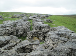
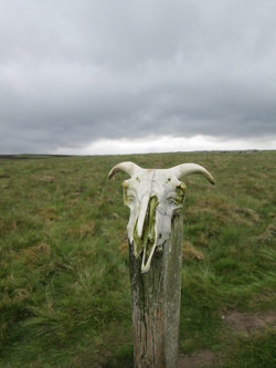
At 662m, Nine Standards is the last of the really high climbs (but that's not to say it's downhill all the way to Robin Hood's Bay!) And although the descent was not steep it was utterly wet and boggy - crying out for some attention before it erodes too much further. The Pennine watershed is basically a giant sponge and the guide sensibly advises to "avoid the worst bogs by all means possible: backtracking, taking a running jump, using a pole, using your partner as a plank; whatever works for you." Well, Pete wasn't available and I had another comedy fall, but at least this time with a soft landing (my butt is still vivid purple from the last comedy fall on Kidsty Pike). As I followed Ney Gill towards the head of Whitsun Dale, I spotted a black bothy hut and went in to eat my snacks on the wooden tables and benches. I was joined by the "Richmond Ramblers," the oldest of whom was 80 and has only just stopped working as an official guide due to the insurance costs. Fair play and I hope I can stay as fit and agile at 80! They advised me to take the high route again tomorrow, but I am tempted by the easy riverside alternative at this point...will decide in the morning. 
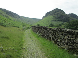
The route then contours Cotterby Scar above the River Swale to drop down to the Tan Hill (highest pub in England) road just west of Keld. The hotel here used to be the Youth Hostel but is now privately run and very nice it is too. Coffee and white chocolate flapjacks on arrival. I've ordered fisherman's pie for dinner and am enjoying a pint of Black Sheep 'All Creatures' pale ale as I type. There's a huge drying room here, so socks washed again and a couple of tops. Today's internal radio gaga included Erasure "Respect," Oasis "Some Might Say" and the Beatles "Across the Universe." 2.6 mph today was pretty good as it was so boggy. I can understand why there are tales of sheep and calves being swallowed up. Thank goodness I only went in ankle deep (so many times). Odometer 12.2 miles Cumulative Miles 107 Total Ascent 1196 metres Total Descent 854 metres Moving Time 4h 40 m Stopped Time 2h Moving Average 2.6 mph
0 Comments
The walk to Kirkby (pronounced Kirby) Stephen was pleasant enough as it transited field and moorland across the Upper Eden Valley and the Howgill Fells. AW mentions several prehistoric sites along the way, though I would agree with the Stedman guide that none of them will make you drop your jaw in amazement, and if you didn't know about them you'd probably pass by none the wiser but still cheered by another great day aboard the C2C path. Best of all though, it didn't rain today! As a case in point, may I present to you the stone circle just outside Orton. It's not exactly Stonehenge. I think the sheep were quite amused to see me even bothering with the camera there. Apparently this is even more impressive than one I missed yesterday. From here, it was a simple case of heading east all the way, across Tarn Moor to the bird hides at Sunbiggin Tarn where lapwings, curlews and oystercatchers were seen. Also the group of 20 or so cyclists that were making a racket at my hotel in Orton last night (but that was thankfully the last I saw of them). It was then a matter of tracing dry stone walls across Ravenstonedale Moor with its limestone escarpments to reach the 'Severals,' another important yet barely recognisable important archaeological site. The sun was peeping through at this time, but there were still dark clouds overhead. Having been bitten practically to death by blasted midges in my hair yesterday I wore a hat today thinking to foil them. But the blighters just bit my neck instead. I think the hat did serve as a kind of thinking cap though as my thoughts did have a bit more of a meaning of life bent today (in a good way). Once the settlements have been thoroughly examined (by walking straight past them), the route drops down across Scandal Beck, and I got a wonderful view of the Smardale Gill viaduct before heading up Smardale Fell. The viaduct was part of the South Durham and Lancashire Union Railway and was closed in 1962. It fell into disrepair but is now a listed building maintained by charitable trust. I may have said it before, but I do like a good viaduct. I was looking out for the 'Giant's Graves' (pillow mounds) on the side of the fell but although I saw them, they are not a patch on the barrows we have in Dorset! And then to the ancient market town of Kirkby Stephen in plenty of time to see the giddy sights, and to be fair there is a lot of history in the town, much of which is a designated conservation area. I called into the King's Arms for a half of Dent Brewery's Aviator and a bag of crisps, but was put off eating dinner there by the effing and jeffing of the Saturday night lads out brigade. So I stocked up at to dine a la carte from the local store and treated myself to some of the handmade chocolate that I just had to buy in Orton. And now for some R&R ahead of tomorrow's big day when we go up and over the Pennines. On the internal juke box today: The Clash, "Police and Thieves," Buggles, "Video Killed the Radio Star" and Boomtown Rats "Diamond Smiles." Retro. Odometer 14.1 miles Cumulative Miles 94.8 Total Ascent 482 metres Total Descent 497 metres Moving Time 4h 54 m Stopped Time 1h 54 m Moving Average 2.9 mph A bit of everything today: the very tail end of the lakes, the busy motorway crossing marking this, a taste of the Peak District, desolate moorland, and peaceful villages nestling at the foot of the Howgill Fells. It was raining when I woke up, and continued to rain for the most of the day. I was glad to have stayed in Bampton last night, although it made today's walk that bit longer. Quite apart from the excellent B&B, the little village itself was very pretty, the walk along the River Lowther to rejoin the route at Shap Abbey was lovely, and Shap wasn't all that much to look at when I did get there. It also meant that I could spend time at the Abbey, which even managed to do in one of the brief dry spells the weather afforded me today. The Abbey has the distinction of being the last Abbey to be founded in England in 1199. It was also the last to be dissolved by Henry VIII in 1540. There is a tiny stone coffin there of one of the Abbots. In other news, a Coast to Coast hiker suffered a vicious attack involving charges of GBH (Grappled by Hen). I got mugged by a chicken. Seriously. I was having elevenses at the ruins of Shap Abbey, enjoying my flask of coffee and half a cereal bar when a gang of free range raiders approached. One brave hen jumped up on to the bench, stole the other half, ran off with it and shared it with her feathered friends. The cheek of it, I was looking forward to that. Whatever next I wondered - burgled by badgers, robbed by rabbits, set-upon by stoats (etc)?? Took this mug-shot of the speckled offender at the scene of the crime. Leaving Shap, it is a shock to the senses to encounter the M6 after so many days with hardly a road in the Lakes. It is soon left behind to climb over a limestone plateau and cross the heather moors around Crosby Ravensworth Fell. This is difficult country to navigate as there is little in the way of landmarks and the route is not marked on the OS maps. This is where the GPS saved the day again. The wind was biting over the moors, the sky was black and the rain just poured down. Loved it! Here I have created my own interpretation of Damian Hurst's work, which I am hoping to display at the Tate Modern and sell for several million pounds... The path across the moors seemed to continue on and on and I got to the point where I was beginning to wonder if Orton actually existed at all. Perhaps I was doomed to wander the moors like a lost soul until it was my own pecked clean skull that a future hiker would be putting on a post, taking photos of and thinking they were being artistic. At least the rain had cleared by now. I was making steady progress on my bag of liquorice allsorts, but was disappointed to find only one orange one and way too many of the bobbly aniseed ones. Funny, I had thought that I would spend my time contemplating the age old questions, finding a way to world peace and resolving third world poverty but no, it was merely the state of modern confectionery and a desire to kill all midges. But eventually my destination came into view, and very welcome it was too. It was a shame that the handmade chocolate shop was closed though, I might wait until it opens before heading off to Kirkby Stephen in the morning. Should be a good day for it as the weather is set to improve. Good pace today, bowling along mostly to Lightning Seeds "Lucky You." Odometer 14.5 miles Cumulative Miles 80.7 Total Ascent 483 metres Total Descent 458 metres Moving Time 4h 48 m Stopped Time 3h 33 m Moving Average 3.0 mph Today I left the Lake District with mixed feelings. My guidebook said that it wouldn't let me go without a struggle, and it was certainly one hell of a tussle. Whilst I have loved walking in the crags, knotts, pikes and fells, I am also looking forward to some level, less punishing walks. By the way, there are no Patterdale Terriers in Patterdale. I popped into the village shop to get some chocolate to go in my handy bag, as it is a pain to take the rucksack off every time. Glad I did, I needed all the energy I could muster. Angle Tarn This morning's walk started with the ascent to Boredale Hause and up to Angle Tarn. That was gruelling straight after breakfast. I really struggled to get going today, but was fine once the path became less rocky and really began to enjoy myself once out on the open fells again. So much so that I decided that a mere 12 miles planned with just the one pike (Kidsty, 784m) was just not challenging enough and went off my planned route to bag Rest Dodd (696m) and The Knott (739m) as well. This didn't add a lot of extra mileage, just more height and eventual leg ache. Although it did 'confuse' the GPS which was telling me I was going in the wrong direction (which of course I was, but only according to the route I had loaded in). Incoming weather from the west I had left Patterdale in good weather, expecting light rain as per the local weather forecast. Fair enough, me thinks, I knew the sunshine couldn't last. It started drizzling then got heavier. I stopped to don full waterproofs before bagging my extra Pikes. I had also planned a detour to High Raise (802m) until I saw the weather coming in. The rain probably was 'light' in Lake District terms, where it's an average of 130 inches of rain fall each year in Borrowdale; but it sure felt like it was nissing down to me. Visibility got poorer as the rain got heavier and the mist came down. Having already 'confused' the GPS, I missed my turn off for Kidsty Pike as I descended the Knott and carried on the old Roman road of High Street, heading back south for a while instead of east. The bonus of the GPS is that I soon realised I was wrong and was able to correct the error quickly. Not so for a couple who I saw going up as I came down and who I later found out were C2C'ers. They are probably still up there. As I turned on to the path up Kidsty Pike, I saw a man and his mum coming down to join the same path. He was wearing jeans, trainers, a fleece and a polythene poncho like you get at Alton Towers. She at least had boots on and a green cycling cape. You have to wonder. They had no map or compass, only a guide book and no idea where they were going. It was their chums who were going along High Street in the wrong direction. I showed them the path and walked in front of them so they could follow my red rucksack cover as by this time the visibility was down to about 30 feet. I was cold and very wet, but I had an energy boost as I scoffed half the bag of chocolate mini eggs bought earlier. There was no view from the top of Kidsty Pike. Fortunately, the rain let up and the mists cleared for the rather gnarly descent to Haweswater Reservoir. There is a flooded village under there, which you can see at times of very low water, so not likely today then. I had a couple of comedy falls slipping on rocks on the way down, so my bruise collection is growing nicely. I found a spot out of the punishing winds and finally got to my coffee and lunch. Couldn't sit still too long though - need to keep moving to stay warm. Dropping down to the water, the path then undulates (a lot) for 4 miles above the shore line of Haweswater and under the crags of Bampton Common. By the time I got to Burnbanks at the end of the reservoir, I was so glad that I only had another mile or so to head up into Bampton, rather then another 4 to get to Shap, where all of the other C2C'ers I have been walking with so far went. Haweswater from Kidsty Howes As I headed to Bampton, it was obvious that the only pub in the village, despite still having a sign that said 'Always Open' was closed. I arrived at my B&B (The Village Post Office & Shop run by the amazing Janet and John) at 6.15pm, cold, wet and tired. Janet offered to phone ahead to Bampton Grange and book a table for me at the pub there, but said that I would need to head over there straight away - no time to shower and change. I couldn't face another walk, even if it was just for 10 mins, and I was too wet to be comfortable. I still had supplies in my case and said I was just going to have a bath and stay in. Janet offered to make me a sandwich, but because I felt that was imposing, I asked if she perhaps could let me have a bread roll? Meanwhile, John showed me to my lovely room - fantastic bathroom, and took my request for brekkie in the morning (I fancied sausages). 20 mins later Janet came back with a plate of cheese and tomato sandwiches, a salad with dressing, a packet of crisps, a bowl of strawberries and blueberries and a yogurt. I couldn't thank her enough and she refused to take any payment for such a lovely supper. Such kindness and hospitality I certainly won't forget. One hot bath, a chat with Pete on Skype and a catch up of last night's Apprentice on iPlayer and I'm ready for a lovely deep sleep. I am amazed at today's stats as the paths really were hilly. A note on the stop times, as they may seem high: It's not just me sitting in the sun (!) for several hours instead of walking. The GPS takes account of all times when you are not moving along the grid references. So every time you pause to read the map, look at the scenery, re-tie boots, adjust kit, faff, wee wee etc. is all counted as stopped time. So there you go (or stop as the case may be). Today's tunes pop-pickers were ELO "Wild West Hero," Eurythmics "Here comes the rain again", Crowded House "Four Seasons in One Day" and of course Haircut 100 "Love Plus One" (as in Where do we go from here, is it down to the Lake I Fear?). Odometer 14.8 miles Cumulative Miles 66.2 Total Ascent 1045 metres Total Descent 1057 metres Moving Time 5h 54m Stopped Time 3h 58m Moving Average 2.5 mph Glorious weather today for a simply stunning high level walk. Slept well in the luxurious B&B last night, had a light breakfast of fresh fruit salad with yogurt and granola followed by eggy soldiers, met the cats and set off about 9.30. The cats were all black and very rotund. Oscar took a liking to my suitcase and kept trying to get in it, which is just what Henry does. BTW, not sure if something weird has happened with the posting dates, but for the observant among you, Day 3 was 25th June. Grisedale Tarn As soon as left Grasmere was straight into a steep ascent of Great Tongue (yes, really) following Tongue Gill up to the waterfall at Grisedale Hause (570m). I sat and drank my coffee with 2 ladies from Ulster who were supporting Duke of Edinburgh Awards expeditions. They were telling me about the walks around the Antrim Coast and reminded me that I must see the Giant's Causeway. From the high point it was a drop down to Grisedale Tarn and the first glimpse of Ullswater below. The tarn is flanked by Dollywaggon Pike and the Helvellyn range on one side, with St. Sunday crag on the other. The low route follows the valley floor. St. Sunday Crag with Striding Edge behind me Having tackled Helvellyn via Striding Edge with Pete a few years ago, I knew how steep, narrow and slippy it could be and didn't want to do it on my own. So I opted for St. Sunday Crag and was glad that I had. AW calls it 'a mountain for connoisseurs.' The climb up wasn't too bad, the ridge walk was stunning as the ground dropped away to the valleys either side and the panoramic views from the summit (841m) were just amazing on such a clear day. I recognised Pillar and Scafell Pike to the west; Kidsty Pike was on the east, but that's a walk for tomorrow. The path then descended very steeply to Patterdale, my right knee is feeling the strain a bit. But tomorrow is the last super-hilly day as we say farewell to Lakeland and head for the Dales. Ullswater Meantime, I arrived at my B&B with plenty of time to do some washing of the stinky walking socks, some tops and a fleece. While I was hanging them on the line to dry, the resident spaniels came to ask for a game of fetch. Boy spaniel got a bit over excited and started to hump my leg. I hope there isn't an extra charge for that! Popped to the White Lion for a light dinner and a pint of their own ale then managed to speak to Pete on Skype while Henry and Tigger walked in front of the camera giving me a view of their bottoms. No extra charge for that either. Washing was still wet, so have hung it over radiator racks and am hoping no to have to pack it in wet on the morrow. And now for the stats bit. Speed picked up again today, which bodes well for the longer stage tomorrow. Songs of the day were The Jam's "When You're Young" and Manfred Mann "Davy's On The Road Again". Odometer 9.4 miles Cumulative Miles 51.4 Total Ascent 966 metres Total Descent 887 metres Moving Time 4h 14 m Stopped Time 3h 36 m Moving Average 2.2 mph I was a bit concerned this morning when I got out of bed and walked with a definite lurch to the left. I was glad when I realised that this was due to the floor sloping in the 400 year old B&B and not down to some form of horrible and as yet medically undiscovered muscle injury. I slept well, although the burning feet and sore knees and quads took a while to settle down, and I woke refreshed and ready for another day. I was determined to stick to the high level alternative again today but as it was a short walk I planned to take it slowly - no jarring, strains, hammer toes or hot spots. Today's efforts started with a steep climb up out of the Borrowdale valley. I stuck to my plan and didn't make haste (but I don't think I could have even if I wanted to). The path follows Greenup Gill with its many waterfalls and tributaries to cross. Good way to clean the boots. Eagle Crag (525m) is on the right and looks huge from the valley floor, but by the time I got to Greenup Edge I was looking down on Eagle Crag. Ha. As I climbed, the views back down to Borrowdale were amazing. The climb got steeper again beyond the waterfalls then dropped into a basin of drumlins which are mounds created by glacial action. Then another steep climb to pass up and over Lining Crag (500m) and on to Greenup Edge. From Lining Crag you can see right back to the Coast. From Greenup Edge (620m) the ridge walk takes in Calf Crag (538m), Gibson Knott and Helm Crag amongst others; each with better views of Grasmere, each giving panoramic views of the eastern lakes beyond. There are plenty of the local Herdwick sheep who are born black but become white and grey as they get older. In between they go through a stage of having a brown body and a white face which confused me as I had begun to think that some of them were cows (in a Father Ted sort of way - these sheep are very small; those sheep are far away). They are very cute and I was sorry for continually disturbing them. I wondered if they kept thinking 'bloody grockles'. Probably just grass, wolf, grass, wolf, grass, wolf and so on. The way continued over peat bogs and rocky steps and is very wet in places to say the least. Both boots went in ankle deep at some point! By the way, songs of the day on the internal iPod today switched between REM 'Superman' (which I guess popped into my head with a nod to yesterday's efforts), Bowie's 'Queen Bitch' and of course 'Panic' by The Smiths...Hopes may rise over Grasmere and all that. I took a lunch stop at Moment Crag, took my boots off, lay back in the sun and watched as three ravens flew by so close I could hear the air moving. Arrived at picturesque but touristy Grasmere just before 6pm and took a stroll around the busy village to see where Wordsworth is buried after he ceased wandering lonely as a cloud; stocked up with lunch supplies and bumped into fellow walkers for a coffee and a jolly good laugh as we exchanged updates at the bistro where they had finished dining and were supping the last of a bottle of red. I myself dined a la Co-op meal deal as I was not hungry enough for a pub meal. My B&B tonight is all boutique designer and very swish, I am terrified of turning round with my rucksack on and breaking something. There are two black cats here which I am assured of meeting tomorrow. One thing I have remembered so far is to charge up the batteries for everything and to take plenty of piccies, which I usually forget or can't be bothered to do. I told Pete that I will make a series of postcards up called scenic places I have weed at. Today's stats are almost embarrassing, but at least they are deliberately so and I have awarded myself the ISO1234567890 and various EU standards for energy conservation: Odometer 8.61 miles Cumulative Miles 42.0 miles Total Ascent 705 metres Total Descent 783 metres Moving Time 4h 31 m Stopped Time 3h 53 m Moving Average 1.9 mph According to Wainwright (AW) himself, I am superhuman. He labels the alternative paths I took today as a 'route for supermen' and advises that this is 'a delectable route in clear weather (only) for very strong and experienced fell walkers (only).' My navigation skills were tested, I was on my hands and knees at some stages, but was so pleased with myself afterwards! As superman (non gender-specific), my special power seemed to be the ability to turn my nose into a tap and my kryptonite was chocolate. I would actually have mugged someone, I was that desperate. But at least I didn't walk with my pants on the outside of my trousers. Apologies in advance for the long blog today, but what a day. The walk started with a stroll alongside Ennerdale Water, very pleasant with the sun shining (The Beatles "Good Day Sunshine" was song of the day in the internal iPod). It was a bit rocky in places and whilst clambering over one particular high point my flask fell from my rucksack and bounced down the rocks, but fortunately not into the lake. It is now a bit bashed and scratched which crater shall henceforth be known as the 'Ennerdale Dent.' Saw a pair of grey wagtails (tick). The low level path (for ordinary mortals) was through forest for quite a way, which put me off (as in why come all the way to the Lakes and then walk through pine trees), and as AW preferred the high ground then that had to be the way for me. And so I turned off to ascend Red Pike (755m) and here began my version of the tortoise and the hare. As I climbed, I was overtaken by about 6 or so other walkers, whom I watched rapidly tracking right high above. At this juncture I was thinking that a tortoise or a snail or a sloth would actually be moving faster than me. I got to the bit where they had turned but it didn't feel right and so I doubled back, remembering the advice that turning too soon would lead to dangerous scree and if in doubt, to keep going up. There wasn't really a path beyond this alleged turn, but there was a line of cairns which came into view to follow to the top. Mind you, the slope was so steep I was in doubt in places that the cairns were even correct. But I made it eventually and my reward was stunning views back to Ennerdale and across to Crummock Water and Buttermere. I had 'beaten' the hares as they did not, in fact, summit Red Pike. I felt suitably smug. I rested in the sun at the tarn for a while. AW suggests that from here, you ignore the more obvious route to Blackbeck Tarn and take an unmarked route down to meet the top of Loft Beck so as to rejoin the ordinary mortals on the lower route. Well, I couldn't get my head round that, so carried on the obvious path instead. And so now I know why the guidebooks say to ignore it! The path is reasonably clear, but it is so steep there were a couple of times when I was a bit scared. Often the path would simply disappear as it abutted a vertical rock-face. It was only when you craned your neck back and looked up that you would see a small pile of stones to mark the way. This is where hands and knees, fingernails and toes came into play and there were several mutterings of 'I am not a sheep'. I only saw one other person who gave me some helpful advice to 'look for the polish' where other peoples' steps had made the edges of the rocks smooth and shiny. We soon parted company at Little Round How (surely named with more than a hint of irony at 500m) and I climbed more gently to the disused drum house of the Hopper Slate Quarry, where I saw my first ever Ringed Ouzel (big tick) and on to the Honister Slate Mine which was re-opened in 2001. The cafe there had long closed, which was a shame as I was murderous for chocolate. I still had 4 miles to go and time was getting on. It was, at least, downhill all the way as I followed first the mine access road and then the 1 in 4 Honister Pass alongside the very pretty Hause Gill into Seatoller. From the phonebox I called first Pete and then my landlady to say I wouldn't be there until about 8.30 and that I would just nip in and straight back out to the pub for dinner. Good job I rang as she said the pub was shut on Mondays...imagine if I had missed a proper dinner after all that effort. She said to carry on to the Scafell Hotel in Rosthwaite, where I met up with other C2C'ers who were looking out for me. I feasted on fish and chips and a couple of pints of Ambleside Golden Ale. I also bought a couple of bars of dairy milk to take with me over forthcoming days. But I ate them both in bed when I got back to the B&B!! I had definitely earned them. And so I went to sleep tired and aching and satisfied and proud of myself. Now that's what I call fell walking. I think today's stats show a healthy pace all things considered: Odometer 17.1 miles Cumulative Miles 33.4 miles Total Ascent 1440 metres Total Descent 1492 metres Moving Time 7h 8 m Stopped Time 4h 58 m Moving Average 2.4 mph If I was hoping for an easy walk to start me off, then I was wrong! Tough climb today, but what excellent views as I left the coast behind and started to head East into the lakes. Left the B&B at 9.30 and headed down to the start of the walk via the Priory to get a couple more photos. Dipped my toes in the Irish Sea, saw the RNLI lifeboat being launched, said farewell to my darling hubby for the next 14 days and set off up the cliffs towards Whitehaven. I was really pleased to see large numbers of Razorbills at the cliffs which form part of an RSPB reserve beyond St. Bees lighthouse, I was also jolly pleased that the westerlies were bringing clearer skies. As you get nearer to Whitehaven you can see the giant nuclear power plant at Sellafield to the north, and some equally conspicuous chemical works to the south, but they don't detract from the coastline. I left the coast and its industrial scars behind and turned inland to cross through the pleasant village of Sandwith and the rather non-descript old mining villages of Moor Row and Cleator. I spotted my first Yellowhammer of the year (tick). From Cleator the long, long climb up Dent Hill starts, initially through forest tracks and then up on to open hill country. Looking back from the summit (353m, felt higher) you can see across the whole of the Cumberland coastal plain, to the Isle of Man and over the Solway Firth to the Galloway Hills of Scotland. Thank goodness for a clear view! But the real winner is the first view of the Lakeland fells that is the reward for the long climb, even if some of the higher peaks (Scafell Pike included) were under cloud. It was cold and windy up there; wet and boggy underfoot. My attempts to capture the peaks were thwarted as I couldn't hold the camera still in such high winds. I contoured Raven's Crag then reached what can only be described as a precipice. The descent was exceedingly steep, so much so that irate readers of the Stedman Guide apparently still write in and complain about the gradient (have they not used an OS map?) From there it was a simple case of following the charming Nannycatch Beck along then a slight climb out to meet the road to Ennerdale Bridge at Low Cock How Farm. I wondered if that was a rhetorical question. There is a fine example of C2C signage there! Is the farm sign like a gong so as to call the sheep to dinner? I also wondered if Nannycatch was so called because someone's grandma fell over and rolled down the hill. Swifts, swallows and house martins flew so close you could almost reach out and touch them. Downhill all the way to my quaint B&B "The Cloggers," a bath, with Radox provided (hurrah), then a light supper and a pint of Thwaite's Wainwright's Ale at the Shepherd's Arms. I met up with some people that I had seen walking earlier to compare ornithological and walking notes. Tomorrow is set fair, I think. I was very glad to have stayed dry today and hope it continues. My legs are feeling that steep descent though. A good night's sleep will restore them ready for tomorrow. And now for the stats bit: Odometer 16.3 miles Cumulative Miles 16.3 Total Ascent 1124 metres Total Descent 1065 metres Moving Time 5h 32 m Stopped Time 2h 12 m Moving Average 2.9 mph A safe but long drive from Bournemouth to St. Bees, broken by a surprise detour to Mum's in St. Helens. It was lovely to see her, even if it was just a flying visit. The last hour of the journey was through some splendid scenery, hugging the shore of the Irish Sea on one side and the hills and valleys of the western lakes on the other. Can't wait to hit the trail. How heavy can one small case be?? As soon as we had checked in to our B&B (our room was actually a self catering flat, very spacious), we headed into the village to find the start of the walk. I hope the weather isn't a taste of things to come as it was very windy and raining heavily. The hilltops were shrouded in mist and black clouds loomed. Can only get better (famous last words!) It also noticeably colder than 'dahn sarf' and so I have prepared several layers and full waterproofs for tomorrow. Statue of St. Bega. I'm the one on the right. St. Bees is named for St. Bega, an Irish princess who fled her homeland somewhere between the 6th and 9th century to avoid an arranged marriage. St. Bega lived as a hermit and became renowned for the good deeds she carried out for the locals. Legend has it that she approached Lord Egremont for land to build a nunnery. He said he would grant her as much land as was covered by snow in the morning; a bit mean as it was midsummer's day. Miraculously the snow fell overnight and the nunnery was founded. The village is dominated by the Norman priory and the Grammar School, set around an elegant quadrangle, which was founded in 1583 by the then Archbishop of Canterbury. Pete selected a pebble for me to carry to Robin Hood's Bay, which I will deposit in the North Sea in order to confound future geology students. We had a very tasty lamb shank dinner washed down with a pint of Jennings Summer Pale Ale, I swotted up on the maps for tomorrow and we headed back for a bath and an early night.
Lunch stop at Badbury Rings
OMG - this could be my last walk before the C2C, which has come around pretty quickly. Whilst walking to work on Thursday morning, the magnitude of the challenge seemed to dawn on me and I felt a teeny bit overwhelmed. But only for a moment as all this practicing has done me proud and I'm ready to take it on! Today was planned as a leisurely walk with hubby; didn't want to risk damaging any body parts this close to the off. Annie and Grae came along and we set off from the charming village of Shapwick around noon. It started to pour down almost immediately and we were contemplating turning back and heading straight into the pub. It rained all the way up to Badbury Rings (another Iron Age fort, love 'em) and so rather than walk around the embankments, we headed straight to the trees at the top to get out of the rain while we had our lunch. The tree next to us was home to a family of greater spotted woodpeckers, with the parents coming back to feed the chicks, who were constantly crying for food. Shapwick Fortunately it stopped raining and turned into a sunny afternoon, although very blowy. We dropped down from the rings into the Kingston Lacy estate and followed old drove roads to pick up the Stour Valley Way towards White Mill. The grass was very long in places, nothing like the quagmire I encountered the last time I passed this way back in March. We followed the river and crossed fields to come back into Shapwick for a pint of 'Dorset Tit' (of the feathered variety) strong cider that I had to water down with soda water. Such a wimp these days. Back home about 5 pm. Made some flapjacks and weeded the gardens. Pete wanted to go out with his remote control cars, so I went along for another 3 miles or so walk around Hengistbury Head. I also got used to the new camera ahead of next week, so a fruitful and enjoyable day all round. Might get one more walkies in tomorrow, depending on the weather. Packing next week. Excitement mounts. No walks this weekend, apart from a couple of miles along the seafront at Exmouth with Woody, my sister's German Shepherd. I went down to Devon after work on Friday night to spend the weekend at Lin & Mike's. Weather was brilliant all weekend, we were up at the stables watching my great-nephews have their riding lesson on Saturday, and down on the beach today. Today's paddle was a bit warmer than Swanage last week! Enjoyed a glass of fizz for Linda's birthday. Sorry to have to get back for work tomorrow, but so good to see Pete back from his jolly in Ibiza, have really missed him this week. Only one more weekend free before the C2C!!!
Corfe Castle from the village
Early-ish start today as a long walk planned. Got to Corfe Castle at 10 am. The ruined castle on a hill above the village is said to be one of the most romantic ruins in the country (apart from me that is!) After the 12 miles yesterday, which were rather hilly, my left knee was a bit tender and I was definitely aware of it by close of day. Having set off, I got no further than the village square when had to stop as the smell of fresh bacon baps from the bakery was too good to walk past and indeed it was £2 very well spent. I headed off over East Hill and Nine Barrow Down towards Swanage. There are actually 23 Bronze Age barrows on the down altogether; at one section there is a cluster of eight tumuli and a long barrow. Walking among these was really evocative of being part of the land and aware of the ancestors. After the descent at Ulwell, it was a very steep climb up to the obelisk at the top of Ballard Down (I could have taken the easier ascent, but where's the fun in that?) I cut down towards Studland so that I could round the head at Old Harry's Rocks. It was heaving there - going full pelt with 2 trekking poles obliging foreign language students to stop looking at their phones and get out of the way made up for the crowds somewhat. Then back up t'other end of Ballard Down and along the coast path to Swanage, where I stopped for lunch and a paddle - sea very cold.
And then it was along the coast path past the delightfully named Tilly Whim caves, the lighthouse at Anvil Point, Dancing Ledge, the old quarries at Seacombe and Winspit and the chapel on St Aldhelm's Head. There are amazing views from the head across the cliffs to Kimmeridge and beyond on the left, with the isle of Purbeck on the right. Glorious, with the sun glinting off the sea. And then the steps on Emmett's Hill. This is they - I have never had the patience to count them as I would have to keep starting again and I think I would asphyxiate. Take it from me, they are very steep and there are about 400 down one side and up the other. From there, I crossed West Hill with another steep descent to the lovely farm at Hill Bottom. By this point my left knee was very painful, so will be taking it easy for the rest of this week. I picked up another part of the Purbeck Way here, a pretty bridleway through woods to reach the lane between Kingston and Worth Matravers. From this vantage point there is a fabulous view down to Corfe Castle nestling between the 2 hills where it stood guard to the principal route through the Purbecks for many years, until destroyed in the Civil War in 1646. It's downhill all the way from there. A wonderful way to round off the walk across fields and finally across Corfe Common, with the castle in view all the while as you drop down to come back into the village. I popped into the Greyhound Inn but didn't fancy their menu and ended up eating fish and chips in the car on Wareham Quay whilst listening to alternative 80's on Wave 105. Heaven. And no blisters or hotspots whatsoever off the new boots. Can't believe only 2 more weekends until C2C.
Maiden Castle
With reference to Ian Dury, quite literally. Today I got my new boots (Meindl Burma Pro MFS, bien sur) and wanted get them on before the C2C, although I knew they wouldn't need breaking in. So I called round to Annie's (Grae being in Cornwall and Pete being in Ibiza) to see if she fancied an afternoon stroll. We set off from Maiden Castle near Dorchester at a somewhat late 3 pm, but the weather was glorious and we had abandoned plans for boring household tasks to take advantage of it. Maiden Castle is one of the largest and most complex Iron Age forts in Europe. It's maintained by English Heritage who keep it in excellent condition with just a few unobtrusive information boards, just as it should be. Evidence has been found of a Roman temple and a grisly late Iron Age cemetery where many of the burials had suffered horrific injuries in attacks or skirmishes with other tribes. We picked up the South Dorset Ridgeway towards Black Down and the Hardy Monument. The Ridgeway is lined with tumuli, and it's easy to see why from the higher ground - the views all around are stunning. We also passed shake holes, which are large conical pits dissolved into the limestone over a long period of time by the action of slightly acidic rain Hardy Monument Well, that's enough history and has covered the 'new boots' bit, so I guess we'd better discuss panties! It was a very hot day, with a little bit of a climb to the monument, so we were grateful to see the ice-cream van was in residence and took a break with a Magnum each. The monument is visible for miles around and is somewhat phallic as you notice it popping up over hills. Could only have been designed by a man....it is apparently designed to look like a spyglass as used on ships, since it is actually in commemoration of Vice-Admiral Hardy of Trafalgar fame, who lived in nearby Portesham. The return leg was on the Jubilee Trail via Hell Bottom, aptly named it would seem. In need of a pee, my companion found a spot tucked away out of sight next to a sheep barn. I waited at a polite distance. There was a cry for help and there she was with runny green sheep poo all over the bottom of her trews. Oh dear indeed. I tried not to laugh, for about 1 second!!! The walk back was equally scenic, with views down to Weymouth and Portland, and although we missed pub dinner (it was 9 pm when we got back to the car) it was worth it to see a pair of hares leaping about in the fields near Gould's Bottom (there we go again!) and seeing the masses of rape flowers being back-lit by the low evening sun as we got back to maiden castle. 12 miles covered - not bad for an afternoon's stroll. |
AuthorI'm Saran and I like hiking (and cats). Archives
October 2021
Categories
All
|